- Height : 5564 feets ( 1696 meters)
- Location : Cameron Highland (Pahang)
- Usually it takes 1 hour to 1 1/2 hours ascent and 50 minutes descent
- Distance : about 1.8 KM
- GPS Coordinate : N4.47813 E101.36100
Getting there
- From Tanah Rata town towards Tapah
- Just after bypass the right junction to Carnation Apartment
- You could see the signboard "Oly Apartment" on your right
- Park your car at the Oly Apartment
- The trail head just after the "Tan's Camellia Garden" (N4.47248 E101.37027)
- Toilet and Bathroom : No
- Parking : Parking Area
- Guide : No
- Permit : Yes
- JPSM Permit Information
- JPSM Contact Information
GPX in Google Map
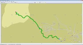
Gunung Jasar Trail Map
GPX Download Link
Download
July, 21 2013
We have planned for Gunung Jasar and Gunung Perdah for so many times and finally we did it this round. Unfornately Gunung Perdah had been flattened for vegetation.
0804 Start Trekking
0810 Turn right at the T junction
0811 Reached a signboard showing "Jungle Walk No. 11, 10, 12"0820 Reached a signboard showing "Jungle Walk No. 11, 10", "Gunung Perdah No. 10 ->"
0907 Reach the tower
0926 Reach Summit
1001 Start Decent
1050 Ending Point
 |
| Gunung Jasar Trail Map |
 |
| Gunung Jasar Trail Profile |


Hi, mcm mana nk hike gunung jasar? Perlu permit x? Perlu ada guide or sweeper x?
ReplyDeleteHi,
DeleteThe path is clear enough...no guide is needed if you have study the trail well....
Officially all mountain required permit before hike...but no one checked during my hike last time.