The
Trek
- Height : 7090 feet ( 2161 meter) N5.14005 E101.48332
- Location : Ulu Temenggor, Kelantan
- Usually it takes 3 Days 2 Nights
- Distance : about 61 KM (4WD) + 16 KM (Trail)
Getting
there
- From Tasik Temenggor via boat ride + 4WD or
- From Lasah via 4WD
- The trail head on Pos Leler, GPS Coordinate (N5.18009 E101.41827)
Facilities
and Fees
- Toilet and Bathroom :-
- Parking : Yes
- Guide Fee : Yes
- Permit Fees : RM 5.00 (Apply in advance)
- JPSM Permit Information
- JPSM Contact Information
Exploring
Gunung Ulu Sepat via Lasah (3D2N)
May, 1~3 2015
Gunung Ulu Sepat with the height of 2161m a.s.l. located on
Temengor, Kelantan. There are two common accessible trail either from Pos
Lelar (Grik) or via Chamah-Ulu Sepat trail (Cameron Highlands). Again
there are two ways of starting point to reach Pos Lelar as below:-
1. From Lasah (a small town about 20 KM away from Sungai
Siput) - Pos Lelar
- Takes 4x4 with 2 1/2 hours ~ 3 hours journey
2. From Tasik Temenggor (Jeti Awan Tasik Banding) - Pos
Khemar - Pos Lelar
- Boat ride from Jeti Awan Tasik Banding to Pos
Khemar with 1 1/2 ~ 2 hours journey
- Takes 4x4 from Pos Khemar to Pos Lelar with
30 minutes journey
A relaxing 3 days 2 nights trip mixture with Malaysia and
Singapore hikers, enjoying different type of hiking experience by 4WD riding,
overnight in Orang Asli Hut. A Day hike to Gunung Ulu Sepat summit.
Day 1 (01/05/2015)
Stage 1 : 4WD ride with bumpy terrain, mostly uncompleted
tar road and dirt terrain from Kg. Lasah
to Pos Lelar
Stage 2 : Trek along farmland under the hot sun with one
river crossing before reaching the forest
entrance
Stage 3 : Long trek with three river crossings before
finally reaching the foot of the mountain to
make the final ascent on next day
Day 2 (02/05/2015)
Stage 1 : Trek all the way up with multiple false peak
before finally reaching the beautiful mossy
forest
Stage 2 : Muddy steep terrain from mossy forest to Ulu Sepat
peak
Day 3 (03/05/2015)
Stage 1 : Trek back to Pos Lelar
Stage 2 : 4WD ride to Lasah
Day 1 Journey
10:38 4WD ride from Kg. Lasah
11:26 Reached Pos Piah - Kg. Kembok (mainly tar road)
11:46 Short break before river crossing (mainly
bumpy terrain with uncompleted tar road)
12:04 Continue
13:00 Pos Khemar (mainly dirt terrain)
13:08 Post Lelar
13:53 Start hike from Pos Lelar
14:21 1st river crossing
14:41 Forest entrance
14:47 Rest
14:55 Continue
15:49 2nd river crossing
16:00 3rd river crossing
16:19 All the way ascent
17:10 last river crossing
17:28 Bamboo terrain
17:35 Reached Orang Alsi Hut
* River and campsite just 5 minutes walk down from Hut
Day 2 Journey
08:37 Journey start
08:42 Reached campsite and river crossing (Sungai
Lenweng)
10:05 Reached false peak
10:58 Reached another false peak
11:42 Reached mossy forest
12:04 Reached Ulu Sepat Peak
13:27 Descent
13:46 End of mossy forest
15:54 Reached campsite and river crossing
16:00 Reached Orang Asli Hut
Day 3 Journey
08:26 Journey start
08:29 Reached bamboo terrain
08:44 River crossing
09:34 River crossing
09:42 River crossing
10:12 Reached farmland (Under hot sun)
10:38 Last river crossing
11:11 Reached Pos Lelar
13:32 4x4 journey start
15:08 Reached Pos Piah
15:59 Reached Kg Lasah
 |
| Kampung Lasah |
 |
| 4x4 Ready for us |
 |
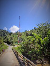
| First section of 4x4 road condition |
 |
| Reached Pos Piah |
 |
| 2nd Section of 4x4 Road Condition |
 |
| Logging Area |
 |
| 3rd Section of 4x4 Road Condition |
 |
| Pos Khemar |
 |
| Finally...reached Pos Lelar |
 |
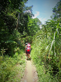
| Start Hiking |
 |
| 1st River Crossing |
 |
| Woow....no more under the hot sun |
 |
| 2nd River Crossing (Campsite) |
 |
| 3rd River Crossing |
 |
| Start ascent |
 |
| Last River Crossing |
 |
| Bamboo Terrian |
 |
| Our guide - Uncle Ming |
 |
| Day 2 Summit Day Hike |
 |
| All the way up, up, up.... |
 |
| False Peak |
 |
| False Peak |
 |
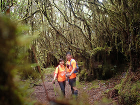
| Mossy Forest |
 | |||||||||||||
| Finally!!! |
 |
| Ulu Sepak Peak |
 |
| Our 3rd G7 |
 |
| Descent |
 |
| Sungai Lenweng River & Campsite |
 |
| Day 3 Head back to Pos Lelar |
 |
| River Crossing |
 |
| Campsite next to river |
 |
| Mission accomplished |
 |
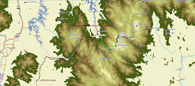
| Overall Ulu Sepat Trail Map |
 |
| Ulu Sepat Trail Map From Lasah / Tasik Temenggor |
 |
| Ulu Sepat Overall Trail Profile (Lasah - Pos Lelar - Sg Lenweng - Summit) |
 |
| Ulu Sepat 4x4 Trail Map (From Lasah To Pos Lelar) |
 | |
| Ulu Sepat 4x4 Trail Profile (Lasah To Pos Lelar) |
 |
| Ulu Seapt Trail Map (Pos Lelar to Sg Lenweng) |
 | |
| Ulu Sepat Trail Profile (Pos Lelar to Sg Lenweng) |
 |
| Ulu Sepat Summit Trail Map (Sg Lenweng to Summit) |
 |
| Ulu Sepat Summit Trail Profile (Sg Lenweng to Summit) |


Hello bro! This is Mike from YellowTukTuk! Been a hiker myself and always was fascinated by your guide. I would like to conduct an interview with you and feature it at our website. I can't seem to find your email in your website but please do let me know how I can get in contact with you.
ReplyDeleteHere's my email: mike@yellowtuktuk.com
Hi Mike, thanks for the invitation. my email : mailbox.mchiker@gmail.com
DeleteHello mcHiker, actually may I know how much you pay a guider for this trip?
ReplyDeleteHai mchiker,
ReplyDeleteGood day to you. This hiking trip was amaze. Can mix around with orang asli. They are few huts at base camp before summit. Is there available for rental??
Thanks in advanced.
Tan
Email: twtan1@gmail.com
Hi Wooi,
DeleteYes. You could arrange with Orang Asli in advance to book the hut and arrange the guide.
This comment has been removed by the author.
ReplyDeleteTq
ReplyDelete