The Trek
- Height : 328 feet (100 meter)
- Location : Tanjung Tuan (Port Dickson), Negeri Sembilan
- Usually it takes 30 minutes ~ 1 hours plus (depends on trail)
- Distance : about 6 KM (The path that I hiked)
Getting there
- Using Waze App search for Tanjung Tuan
Facilities and Fees
- Toilet and Bathroom : Yes
- Parking : Parking Area
- Guide : No
- Permit : No but entrance RM 1.00
GPX in Google Map
Buki Batu Putih Trail Map
GPX Download Link
Download
Exploring Bukit Batu Putih
November, 16 2019
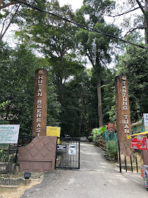
Bukit Batu Putih technically under to Melacca State but is located in Port Dickson, Negeri Sembilan, with the height of 100 meter plus a.s.l. A great hike place for family and beginners which provides you with a panoramic viewpoint with easy hike. There are many paths in Tanjung Tuan Forest Reserved which as easy as 30 minutes hiking from car park to submit or you could start from other paths that round the half / whole area.
The easiest path start from car park follow with the tar road, turn left just before reach the top near lighthouse and follow the jungle path till the end to Bukit Batu Putih.
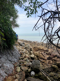
We started from the left junction before the entrance, follow the beach route till limestone area. All the way steep climb to submit. After rest continue descent from lighthouse path to other side of the beach and continue the jungle trek back to lighthouse.
Stage 1: Beach Route
Stage 2: Steep Climbing on limestone
Stage 3: Jungle trek


Hi, Mchiker,
ReplyDeleteThank you for sharing your interesting hiking trips.
Would you be kind enough to email me the gpx file for this Batu Putih Hike- mikeleekc01@gmail.com.
For that matter, your blog will be even better if you share the gpx file for each hike. That would be much welcomed by those who want to try your routes.
Thanks once again and congrats on an interesting blog.